Fig.1 Early non-polarimetric Space-SAR Satellite sensors
 The basic radar technologies to do the job are the multimodal Synthetic Aperture Radar (SAR) sensors, first developed for air-borne sensing implemented as for example in 1978 with the first space-borne digital Sea-Sat SAR which enjoyed great popularity and implementation until these days. However, the NASA Sea-Sat L-Band SAR had severe limitations in that it was of fixed wide swath-width at a single arbitrary polarization (HH) and of rather poor 25m resolution. Sea-Sat SAR was followed by several non-polarimetric space SAR sensors such as the ESA ERS-1 (C-Band, 1991 - 2000), NASDA J-ERS-1 (L-Band, 1992 - 19980, CSA Radar-SAT-1 (C-Band, 1995-ongoing), ESA ERS-2 (C-Band, 1995 - ongoing) and the polarimetrically limited Dual-Pol ESA ENVISAT/ASAR (c-Band, 2002, 0ngoing) as presented in Fig. 1. In the meantime, fully polarimetric multi-modal high resolution SAR systems at multiple frequencies were introduced first with the multi-band AIRSAR of NASA-JPL culminating in the once-only pair of SIR-C/X-SAR shuttle missions of 1994 April and October, which laid the ground work for true day/night space remote sensing of the terrestrial barren and vegetated land and ocean covers using multi-band polarimetric SAR. Thereafter, NASA suspended further development of the basic need for further advancing airborne and space-borne multi-modal SAR imaging techniques except for the SRTM shuttle mission of 2000 February (which may soon be re-awakened), as shown in Fig. 2. The basic radar technologies to do the job are the multimodal Synthetic Aperture Radar (SAR) sensors, first developed for air-borne sensing implemented as for example in 1978 with the first space-borne digital Sea-Sat SAR which enjoyed great popularity and implementation until these days. However, the NASA Sea-Sat L-Band SAR had severe limitations in that it was of fixed wide swath-width at a single arbitrary polarization (HH) and of rather poor 25m resolution. Sea-Sat SAR was followed by several non-polarimetric space SAR sensors such as the ESA ERS-1 (C-Band, 1991 - 2000), NASDA J-ERS-1 (L-Band, 1992 - 19980, CSA Radar-SAT-1 (C-Band, 1995-ongoing), ESA ERS-2 (C-Band, 1995 - ongoing) and the polarimetrically limited Dual-Pol ESA ENVISAT/ASAR (c-Band, 2002, 0ngoing) as presented in Fig. 1. In the meantime, fully polarimetric multi-modal high resolution SAR systems at multiple frequencies were introduced first with the multi-band AIRSAR of NASA-JPL culminating in the once-only pair of SIR-C/X-SAR shuttle missions of 1994 April and October, which laid the ground work for true day/night space remote sensing of the terrestrial barren and vegetated land and ocean covers using multi-band polarimetric SAR. Thereafter, NASA suspended further development of the basic need for further advancing airborne and space-borne multi-modal SAR imaging techniques except for the SRTM shuttle mission of 2000 February (which may soon be re-awakened), as shown in Fig. 2.
 |
Fig. 2 Shuttle SAR Systems SIR-C/X-SAR’1994 and SRTM’2000 |
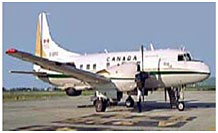
Swiftly the Canadian CCRS, the Danish EMI, the German DLR, the French ONERA and the Japanese NASDA & CRL {now JAXA & NICT} took over introducing and steadily advancing the Convair-580, the EMI-SAR, the E-SAR, the RAMSES and the Pi-SAR airborne highly advanced fully polarimetric sensors platforms, respectively, as shown in Fig. 3.
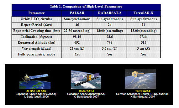
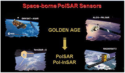
These separate international multi-modal fully polarimetric and also interferometric SAR developmental efforts culminated in a well coordinated group effort of these three independent teams eventually launching and operating Fully Polarimetric Satellite SAR Sensors at L-Band (ALOS-PALSAR launched by JAXA/Japan in 2006 January), at C-Band (RADARSAT-2 launched by CSA-MDA in 2007 December) and at X-Band (TerraSAR-X launched by DLRAstrium in 2007 July).
|
Fig. 4 Comparison of the three fully polarimetric satellite sensors with images |
During the past eight years the development of these satellite SAR sensors had been discussed during the annual IEEE IGARSS meetings, the bi-annual EUSAR conferences and were reviewed most recently in detail during the fourth bi-annual ESA-ESRIN POLinSAR Workshop at Frascati, Italy (also see POLinSAR 2003, 2005, 2007) most recently during 2008 January 26 to 30, http://earth.esa.int/workshops/polinsar2009
|
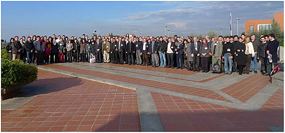
Fig. 5 POLinSAR 2009 participants with author
next to Chair Yves-Louis Desnos YLD WMB |
The impressive images obtained, represented the greatest advancement in space remote sensing since the launch of the NASA/JPL Sea-Sat Mono-polarization SAR of thirty years ago. All of these three satellite sensors provide high-resolution images at close to or better than 1 meter, respectively, and are fully polarimetric in order to be able to differentiate next to shape and scatterer orientation also dielectric parameters of vegetated natural and/or man-made scatterers.
|
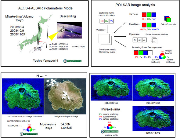
Fig. 6 Representative Example of Fully Polarimetric ALOS-PALSAR Images
using the Yamaguchi 4-Scatterer Decomposition Method |
Such detailed 3-D images cannot be achieved even with the most sensitive highest-resolution Mono-polarization SAR sensors as for example with Cosmo-Sky-Med or the SAR-Lupe, possessing only very limited or no polarimetric capabilities, respectively.
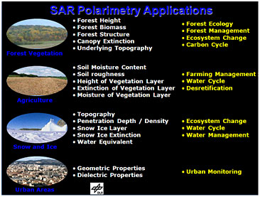
Thus, it is now possible to provide high resolution accurate images and simultaneous characterization of the terrestrial vegetated overburden by implementing the three fully polarimetric Space-SAR sensors as shown in Figs, 5a, 5b and 5c, which is of direct use in agriculture, forestry, nature preservation and in coastal region fisheries, ocean surface mapping, and so on. In addition by implementing repeat-pass co-registrated SAR imaging, it is possible to recover from the resulting interferograms height profiles DEM of the underlying structure as was for example achieved with the single-baseline SRTM Mission (Shuttle Radar Topographic Mission) Fig. 7; and unfortunately its polarimetric capabilities were not fully exercised.
However, by combining polarimetric and interferometric imagery, it is then possible to recover the 3-D structure of vegetated covers in forestry and also in agriculture at resolutions of 1 meter for X-Band from space since SAR imaging resolution depends only on the bandwidth and is independent of the satellite operating height above ground as shown in Fig.8.
 |
 |
Fig. 8 SIR-C/X-SAR, 1994 Oct-11 C-Band POLinSAR Optimization |
Advancements in radar and SAR polarimetry require subtle knowledge of applied vector and spinorial wave analysis, vector electromagnetic and antenna theory, scattering matrix optimization as well as a solid understanding of radar electronic principles and SAR systems technology. This requires rather broad but deep background knowledge and a comprehensive multidisciplinary graduate research education. In order to capitalize on the enormous gain in information recovered on geo-electromagnetic properties of the terrestrial as well as planetary covers, additional pertinent knowledge of geology, geophysics, astronomy and flora is relevant; this in essence defines a multidisciplinary field of expertise in vector (polarization) electromagnet wave sensing and imaging and geo-environmental remote sensing, best described as “Differential Interferometric SAR Polarimetry”. Although enormous progress has been made with results published in many journals, monographs and workshop proceedings, the desired sets of updated text books were missing for either the practicing engineer or for the more advanced research experts. Therefore, based on the historical development of radar and SAR polarimetry, of the existing pertinent monographs, dissertations, handbooks and guides, the aim is to identify the most relevant as well as shortly to appear research and practitioner text books; and in particular addressing topics that need still to be covered and with it the associated sets of books which have now been forthcoming:
| |
Compendium of relevant text books
|
|
Harold MOTT, Remote Sensing with Polarimetric Radar, Wiley-IEEE Press, 1st ed., January 2007, pp309 , ISBN: 978-0470074763 {also see previous books by late Harold Mott, 1986 & 1992}
Boerner, Wolfgang-Martin, Introduction to Synthetic Aperture Radar (SAR) Polarimetry, Wexford Press (reprinted without permission from W-M. Boerner (April 2007), Basics of SAR Polarimetry 1, In Radar Polarimetry and Interferometry (pp. 3.1- 3-40), Educational Notes RTO-EN-SET-081bis, Paper 3, Neuilly-sur-Seine, France RTO, available from: http://www.rto.nato.int/abstracts.asp
Yamaguchi, Yoshio, Radar Polarimetry from Basics to Applications: Radar Remote Sensing using
Polarimetric Information (in Japanese), IEICE Press, Dec. 2007, (soft cover), ISBN: 978-4-88552-227-7, http://www.ieicepress.com/
Masonnett Didier & Souyris Jean-Claude, Imaging with Synthetic Aperture Radar, EPFL/CRCPress,
Engineering Sciences/Electrical Engineering, Taylor & Francis Group, 2008, (hard-cover), ISBN
978-0-8493-8239-4; http://www.crcpress.com
Ya-Qiu JIN & Feng XU, Theory and Approach for Polarimetric Scattering and Information Retrieval
of SAR Remote Sensing (In Modern Chinese), Beijing: Science Press, 2008, (hard cover), ISBN978-7-
03-022649-5; http://www.sciencep.com
Lee Jong-Sen & Pottier, Eric, Polarimetric Radar Imaging - from basics to applications, CRC Press -
Taylor & Francis Group, January 2009, ISBN 978-1-4200-5497-2 (hard-cover), TK6580.L424.2009,
621.3848- -dc22; http://www.crcpress.com {Chinese version to be published by 2009 October}
Cloude, Shane Robert, Polarisation: Applications in Remote Sensing, Oxford University Press, UK &
EU, August 2009, ISBN 978 -0-19-9569731-1 (352p, 260 line-ill: hard-copy),
http://www.oup.com.contact/
vanZyl Jakob-Johannes & Kim Yun-Jin, Introduction to SAR Polarimetry - in progress and to be
completed by 2009 December: To be published with the JPL Series, John Wiley.
Cumming I. G. and F. W. Wong, “Digital Processing of Synthetic Aperture Radar Data”. Artech
House, 653-pages, January 2005. (Published in Chinese, October 2007).
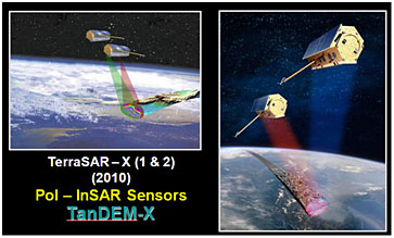
Thus, the next step in the advancement for true polarimetric-interferometric satellite imaging is the development of tandem POL-SAR-Satellite interferometer operations, and because of the required baseline, it is at this state of satellite development not possible to place two SAR antennas with sufficient separation on one and the same platform (space, weight, data-transfer) which was possible for shuttle operation, especially with the extended parasitic antenna boom for SRTM. The first satellite tandem pair is that of DLR-Astrium launching the TerraSAR-Tandem X-Band (TanDEM-X) towards the end of 2009; to be followed by the ALOS-PALSAR-2 in summer of 2010 by forming the ALOS-PALSAR-Tandem 1&2; and then to be complemented with the RADARSAT-3 by forming the RADARSAT-Tandem 2/3 in late 2010. In order to cover the total globe, all of these three satellites and/or pairs are operated in polar orbits with finite swath-width and such that every other orbit is shifted so that after a few days the entire globe is covered by connected image-swaths. The higher the resolution and the more complete the polarimetric scattering matrix acquisition becomes towards Quad-SAR operation, the smaller the swath-width because of the currently available antenna and electronic image data take limitations. For example, operating at only one polarization and with very low resolution of about 100m2 may allow a swath-width of about 400km similar to Sea-Sat, whereas for full Quad-Pol operation at highest resolution of less than 1m2 the swath-width my reduce well below 10 km, and make this mode impractical for continuously covering the terrestrial covers.
This more recently contemplated permanent-looking limitation, has now also been overcome with an ingenious innovation at DLR together with NASA-JPL by using a large reflector with antenna beam-shaping techniques, which will allow for simultaneous multi-band 400km swath width operation at highest resolution and with full Quad-Pol SAR operation; and the horrendous task of quinta-byte (1015) per second image data transfer to ground will be accomplished by new distributed satellite optical data down-link procedures. Some of these new technique will be applied to and tested with the novel L -Band DESDynI/ Tandem-L mission with DLR operating one and JPL the other of these two novel SAR satellite systems (where a similar reflector antenna technique had earlier on be proposed), marking the most remarkable, definite breakthrough since the advent of Sea-Sat in 1978, Fig. 10. This drastic advancement comes precisely at a time when it is now required more than ever before. It will now be possible to register instantaneously, characterize and provide measures for reducing catastrophes following such natural or manmade hazards like the volcano eruption of Pinatubo; the earthquakes in Sichuan province; the Irrawaddy floods of Myanmar; the
|
Fig. 10 DESDynI/Tandem-L with expected images |
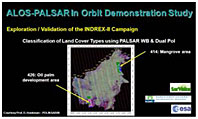
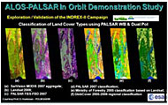
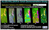
rapid movement of the Antarctic glaciers, mudslides in the Philippines and major avalanches in the Himalayas or the precise detection of oil-spills by tankers illegally cleaning their containers on open sea, and the assessment of the sources of the recent tragic fires in SE-Victoria, Australia; urban sprawl all around the globe and with it wetland destruction; and so on. All of these past dreams are now within our grasp, and as an example some results of the recent Indonesian INDIREX-II Campaign are depicted for the ALOS-PALSAR sensor implementation Fig. 11.
|
|
|
Fig. 11 Results of INDIREX-II Campaign |
In conclusion, international collaboration on advancing day/night global monitoring of the terrestrial covers was demonstrated with the launch of the three fully polarimetric multi-modal SAR Satellites at L-, C-, X-Band, and its tandem satellite-pair updates are forthcoming very swiftly. All of this will be topped by the near-future DESDynI/Tandem-L wide-swath, highresolution fully polarimetric sensor implementation, which in due time will be enlarged to accommodate next to the L-, C-, X- also P-Band sensors using one and the same reflector.
|
Fig. 12 Multiband fully polarimetric Space-SAR Remote Sensing |
The applications will be truly manifold, for example then enabling full assessment also of dense tropical forests which will for example result in curtailing illegal deforestation, Fig. 13
|
Fig. 13 Manifold Applications of fully polarimetric Space-SAR Remote Sensing |
|